Water samples taken on July 21st.
E. coli readings all “acceptable” according to Interior Health (IH), despite slight increases in E. coli counts at Main, Horseshoe and Campers beaches.
Details on the Water Quality tab under Wasa Lake menu item.
Next WLLID Board meeting, 12th August at 7pm, Community Hall, lower level. Residents welcome to attend.
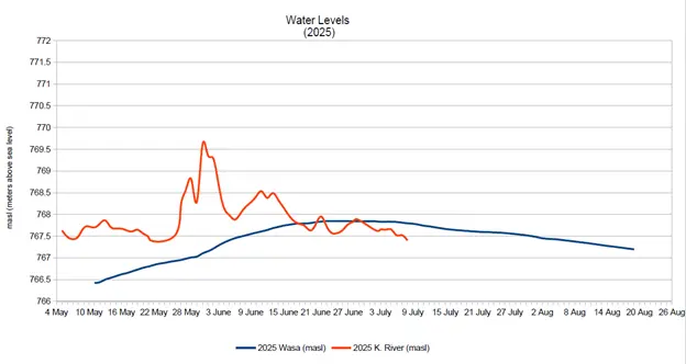
Peak Water Come and Gone
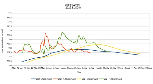
Wasa lake remains low compared to 2024. It reached a peak of 767.84 masl on 23 June and remained there until the 2nd of July.
Only 2001 saw a water level lower than this year when it peaked at 767.50 masl.
As of 15 July, the water level was 767.665 masl, 73.5cm lower than on the same day last year. Recent rains will help keep the lake from falling faster than normal.
While the Kootenay River remains steady, it is also at a much lower level than past years.
WLLID will hold “Water Day” on 26th July, 12 noon to 3pm, at Campers Beach. Come out with the family and enjoy a free BBQ along with water testing demonstrations by WLLID and Living Lakes Canada. Invasive species information and children’s activities will be provided by EK Invasive Species Council.
Families will learn how to keep Wasa water healthy for future generations, including aquatic life. Learn more about RDEK’s flood response and sign up for alerts and evacuation notices here.