To access Board reports scroll down to the Updates box.

A water quantity report (for May 20, 2026) is available in the Quantity Reports box.

The Larratt Aquatic report on water and sediment quality assessment is now available. Go to the Resources tab then click on Reports section then scroll down to the report.

Next WLLID Board meeting, 10th June at 7pm, Community Hall, lower level. Residents welcome to attend.


Wasa Lake Land Development District Logo

Water Quantity

Residents who see or are experiencing flooding, are asked to call the RDEK 24-hour emergency line 250-489-9677.

Updates

20 May Water Update (2026)

May 21, 2026

Water Level Update

While the water here at Wasa began rising a few days before, on April 27th the level reached the WLLID’s lake gauge. This was 15 days earlier than last year when water reached the gauge on May 11th, 2025.

As of 20 May, the water level at Wasa was 767.27 masl (meters above sea level), which was not reached last year until June 3.

Today’s water level is 0.50 meters (1 foot 8 inches) higher than the same date in 2025.

The graph below shows a comparison of current and last years lake and river levels.

Water level updates will be posted on www.wasalake.ca weekly, daily in June until peak.

Also on 20 May, the Floe Lake snow pack was 32.19 inches (snow water equivalent) which is 115% of normal.

The snow pack level at Floe Lake has a significant impact on the Wasa peak water level.

WLLID expects the peak water level to be higher than last year.

On June 1, we will publish an estimate of the peak water level. It will be posted on the website, www.wasalake.ca.

Water Season Ends, AGM Next

October 9, 2025

With the Wasa water season mostly over, the WLLID slows its activity around the lake.

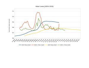
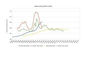
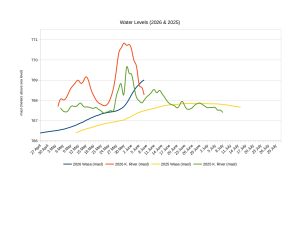
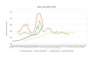
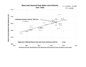
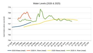
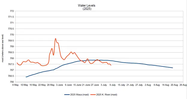
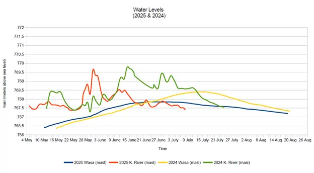
This summer was highlighted by the lowest peak water level, reached on 23 June, at 767.84 masl (meters above sea level), since 2014. this year was the second lowest in the last 25 years. Only 2001 saw a lower peak level, when the water only reached 767.50 masl.

To give you an idea of how low the water was, on 26 July, 2025, the level was 767.55 masl, 53cm lower than on the same day last year.

Last year, the peak water level was 768.40 masl. That’s 56 cm or just over 22 inches more water compared to this year.

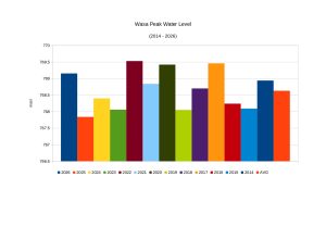
The chart below shows peak water levels since 2014.

Water testing has finished for the season. Dissolved oxygen, temperature and Seechi readings, along with E. coli sampling, will resume in early June 2026. We hope to undertake one or two winter (ice-on) tests depending on volunteer availability, ice and weather conditions.

A detailed review of the E. coli events this past summer was published in last months Buzz. It will be re-addressed at the up-coming AGM.

WLLID has a new website, same address – wasalake.ca.

The Board thanks Shawn at Eggplant Studios for his work on creating the new look and navigation. This makes it easier for the Board to post current news, water data and testing alerts. It will be the public source for verified WLLID Board information.

Past material such as Board agendas, minutes, financial statements and historical reports are still available.

The WLLID AGM is set for 15 October, 2025, 7pm, at the Wasa Community Hall. The Board will present a number of reports outlining the past years activities along with the 2024 financial statements.

Just a few days later, on 18 October, WLLID will lead the return of the shoreline cleanup.

A great day of community activity. Fun for youth and adults alike, roaming the public beaches and bagging garbage.

It all starts at 2pm, meet at the Main Beach parking lot.

Use this link to register https://app.ocean.org/app/cleanup/explore. Search for Wasa Lake under the Join Cleanup tab. Please share this link with other interested parties.

Or, just show up on the day.

A WLLID tote bag will be given to the person with the weirdest item found.

Sur-prizes inside.

Check WLLID website for up-to-date information closer to the date.

August 21, 2025

August 21, 2025

Peak Water Come and Gone

Wasa lake remains low compared to 2024. It reached a peak of 767.84 masl on 23 June and remained there until the 2nd of July.

Only 2001 saw a water level lower than this year when it peaked at 767.50 masl.

As of 15 July, the water level was 767.665 masl, 73.5cm lower than on the same day last year. Recent rains will help keep the lake from falling faster than normal.

While the Kootenay River remains steady, it is also at a much lower level than past years.

​WLLID will hold “Water Day” on 26th July, 12 noon to 3pm, at Campers Beach. Come out with the family and enjoy a free BBQ along with water testing demonstrations by WLLID and Living Lakes Canada. Invasive species information and children’s activities will be provided by EK Invasive Species Council.

​Families will learn how to keep Wasa water healthy for future generations, including aquatic life. Learn more about RDEK’s flood response and sign up for alerts and evacuation notices here.

Wasa Lake Land Development District Logo