The WLLID Board sends out a big thank you to all one hundred six people (106) who participated in the public meeting. That size of turn-out is fantastic. For details, scroll down to the Updates box and click on Public Meeting Hugh Success.
Next WLLID Board meeting, 8th July at 7pm, Community Hall, lower level. Residents welcome to attend.
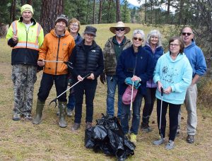
On behalf of the WLLID, a big thank you to all volunteers who helped out on Saturday October 18th picking up litter along the Wasa shoreline.
Not included in the photo were Sherry Shields, Wendy Davis, her daughter Alecia, and grandchildren Chase, Simon, and Arthur as they were still devoted to their task when the photo was taken.
Every piece of trash removed from the shoreline means one less piece of garbage that will pollute our lake!
Everything that is collected is recorded and submitted to Ocean Wise and becomes important data used to inform governments and clean water advocates to help address pollution at its source.
Ocean Wise is a global conservation organization on a mission to build communities that are taking meaningful action to protect and restore our earth’s water bodies.
This year the two most frequently picked items were styrofoam and plastic pieces.
WLLID thanks Trustee Jan for organizing this event.