Water samples taken on July 21st.
E. coli readings all “acceptable” according to Interior Health (IH), despite slight increases in E. coli counts at Main, Horseshoe and Campers beaches.
Details on the Water Quality tab under Wasa Lake menu item.
Next WLLID Board meeting, 12th August at 7pm, Community Hall, lower level. Residents welcome to attend.
On June 5, 2026, the water level at Wasa was 768.79 masl which is 1.385m (4 feet 6.5 inches) higher than on the same day last year.
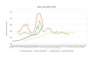
Over the past 7 days the water has risen 1.1 meters or three feet seven inches.
Currently, the water is already 94.5cm (3 feet 1 inch) higher than the peak level last year.
The average peak water level since 2014 is 768.63 masl.
The volume of water added since freshet started is estimated to be 3.26 million cubic meters, or 3.26 billion liters which is the same as 1,300 Olympic-size swimming pools.
Water updates will be posted on the WLLID website every few days as we approach peak water.